


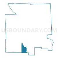
Voting District 020002, Tompkins County, New York
About
Outline

Summary
| Unique Area Identifier | 637967 |
| Name | Voting District 020002 |
| County | Tompkins County |
| State | New York |
| Area (square miles) | 7.46 |
| Land Area (square miles) | 7.38 |
| Water Area (square miles) | 0.08 |
| % of Land Area | 98.87 |
| % of Water Area | 1.13 |
| Latitude of the Internal Point | 42.30575010 |
| Longtitude of the Internal Point | -76.51767310 |
Maps

Graphs
Select a template below for downloading or customizing gragh for Voting District 020002, Tompkins County, New York


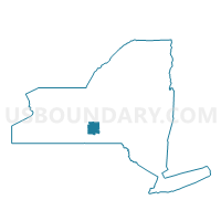
Neighbors
Neighoring Voting District (by Name) Neighboring Voting District on the Map
- Voting District 020001, Tompkins County, NY
- Voting District 080001, Tioga County, NY
- Voting District 090002, Tompkins County, NY
- Voting District 090003, Tompkins County, NY
- Voting District 110605, Chemung County, NY
Top 10 Neighboring County Subdivision (by Population) Neighboring County Subdivision on the Map
- Newfield town, Tompkins County, NY (5,179)
- Danby town, Tompkins County, NY (3,329)
- Spencer town, Tioga County, NY (3,153)
- Van Etten town, Chemung County, NY (1,557)
Top 10 Neighboring Unified School District (by Population) Neighboring Unified School District on the Map
- Ithaca City School District, NY (65,694)
- Spencer-Van Etten Central School District, NY (6,087)
- Newfield Central School District, NY (5,446)
Top 10 Neighboring State Legislative District Lower Chamber (by Population) Neighboring State Legislative District Lower Chamber on the Map
- Assembly District 125, NY (131,678)
- Assembly District 123, NY (124,261)
- Assembly District 137, NY (123,427)
Top 10 Neighboring State Legislative District Upper Chamber (by Population) Neighboring State Legislative District Upper Chamber on the Map
- State Senate District 51, NY (296,420)
- State Senate District 53, NY (295,046)
- State Senate District 52, NY (290,862)
Top 10 Neighboring 111th Congressional District (by Population) Neighboring 111th Congressional District on the Map
- Congressional District 22, NY (679,297)
- Congressional District 29, NY (663,727)
- Congressional District 24, NY (657,222)
Top 10 Neighboring Census Tract (by Population) Neighboring Census Tract on the Map
- Census Tract 19, Tompkins County, NY (6,099)
- Census Tract 18, Tompkins County, NY (5,033)
- Census Tract 101, Chemung County, NY (3,519)
- Census Tract 207.01, Tioga County, NY (3,153)